


Ronnie Reich tries hard to fit a square peg in a round hole. He opens his recent work "Excavations in the City of David" with a chapter "A moment in which to be born" by explaining that the spring, east of the City, was never called Gihon, instead the Bible called it En Shemesh (Sun Spring). On the latter point I completely agree, but disagree on the former. The spring is a perennial gusher, known as an intermittent spring it resembles a pump, sometimes gushing, other times flowing, appropriately and descriptively a gihon (bursting forth or gushing in Hebrew).
Ronnie goes on to relate En Shemesh to sun worshippers of Jeremiah 8:2 and "horses...of the sun abolished by "Josiah (2 Kings 23:11) and that "perhaps at that time the name En Shemesh (Sun Spring) was abolished". Well Ronnie, that is entirely possible, but equally unnecessary because the morning sun still shines on that spring to this very day, and the name En Shemesh does not necessarily denote its association with idolatry.
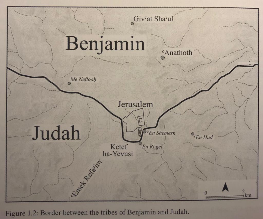
Having said all this, Ronnie ingeniously used En Shemesh to reconcile a difficult, but critical Biblical passage describing an important point on the northern boundary of tribe Judah with the southern boundary of Benjamin. Why is this important?
The Gemara (Zevachim 53b) asks: What is the reason that there was no base on the southeast corner of the altar? Rabbi Elazar says: Because it was not in the portion of land of the one who tears, i.e., the tribe of Benjamin, as he is described in the following manner: “Benjamin is a wolf that tears apart; in the morning he devours the prey, and in the evening he divides the spoil” (Genesis 49:27). As Rav Shmuel, son of Rav Yitzḥak, says: The altar would consume, i.e., occupy, one cubit of the portion of Judah. The part of the altar in Judah’s portion was the southeast corner of the base, and therefore there was no base on that corner.
| SE corner of the altar base, the boundary of Judah and Benjamin |
In addition, there are numerous important Kabalistic and mystical concepts and references to the southeast. But, here Ronnie Reich conclusively resolves that the only portion of land that can possibly intersect the southeast corner of the altar is at the location of the rock-cut-temple on the easter slope of Mount Moriah. Shockingly, the southeast corner of the altars, of the first and second temples, that were built further north, on the temple mount, did not fall within the territory of Judah as depicted in the Ronnie Reich's map above or as stated in the Gemara.


